Home
GPS
Download
Business
Partners
Contact
Family
AVL
Links
History
AsOnTV
Chinese
Croat
Czech
Deutsch
Espańol
Français
Italiano
Magyarul
Nederlands
Nihon-go
Bahasa Malaysia
Wersja Polska
Portuguęs
Romanian
Svenska
Russian
Turkce
Maps & Sounds for Many Countries
Last Updated 1500 Friday 11th September 1998 UK Time
This page tells you something about the mapping that you can download
from this web site for use with GPSS. For 2 years this page was called
"To Those of You Outside the UK" and when GPSS was first released
over 3 years ago, most of our users were in the UK. Now they are worldwide,
and you may contact a few via our links page.
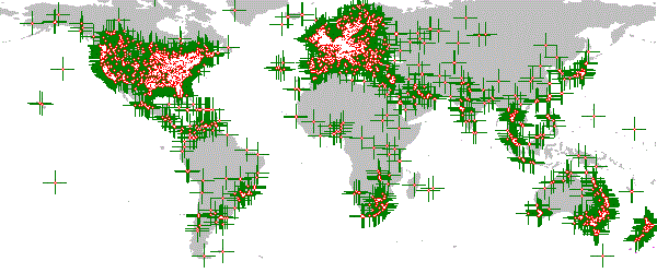
People with GPS you can contact from our Links Page
When someone contacts us from a new place, and has reached the stage of running the GPS Software off this site with a GPS receiver, we upload maps for
them - and anyone else near them. If they are in a new country, then we will normally
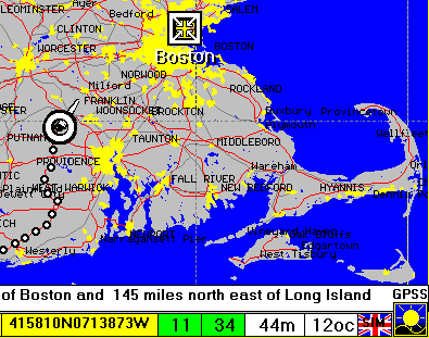
upload maps and sounds covering the whole country. These will normally be based
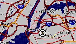
upon Public Domain data, and similar in detail to the Boston map on the left. If available, we will also upload more detailed maps of their home town,
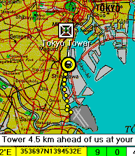 such as the map of Tokyo on the right. These 'bundles' of mapping
are all less than 1.5MB, so that they can easily be copied to floppy disk, and
so the downloading process is not too slow.
such as the map of Tokyo on the right. These 'bundles' of mapping
are all less than 1.5MB, so that they can easily be copied to floppy disk, and
so the downloading process is not too slow.
Very large countries, such as the USA and Australia, have this 'Boston Map' detail in
highly populated areas. Less detailed maps cover the whole
country. The voice description of position, and voice guidance to a place,
is not limited to the detail of the displayed map. The GPSS speech and 'Instrument
Panel' can guide you to within metres of your destination - even if the displayed
map is very poor. The speech can also describe where you are relative to major
towns - and sometimes relative to a local landmark. e.g. "Tokyo Tower" or "Big Ben"
in London. This Tokyo map is used with the permission of
Bartholomew, who provide the maps printed in The Times World Atlas.
 Those of you lucky enough to live in the USA may know that your Goverment
map data is mostly Public Domain. i.e. there are no copyright fees. This means
that, for a few dollars, you can buy a product like Chicago Map Corporations (CMC)
"Precision Mapping 3" (PM3) which has street level mapping for the whole
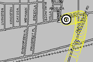
of the USA. These are typical extracts from the samples of the PM3 based mapping
that can be downloaded off the USA Download page.
Those of you lucky enough to live in the USA may know that your Goverment
map data is mostly Public Domain. i.e. there are no copyright fees. This means
that, for a few dollars, you can buy a product like Chicago Map Corporations (CMC)
"Precision Mapping 3" (PM3) which has street level mapping for the whole
of the USA. These are typical extracts from the samples of the PM3 based mapping
that can be downloaded off the USA Download page.
 When this are retrieved by GPSS, a copyright statement is displayed, with a
link to the CMC web site :
www.chicagomap.com
Note that all maps you download from this site ARE NOT FREE OF COPYRIGHT.
You may only download them for free use with GPSS. Even the Boston map
above, based on DCW Public Domain data, is the copyright of Sunninghill Systems.
Businesses, and map copyright owners, such as Bartholomew or Ordnance Survey in the UK, and AUSLIG or Universal Publishing in Australia, have granted permission for Sunninghill Systems
to distibute these samples under strict conditions - such as the copyright statement
that appears when the map is displayed by GPSS. Robin Lovelock is grateful for
their cooperation in this.
When this are retrieved by GPSS, a copyright statement is displayed, with a
link to the CMC web site :
www.chicagomap.com
Note that all maps you download from this site ARE NOT FREE OF COPYRIGHT.
You may only download them for free use with GPSS. Even the Boston map
above, based on DCW Public Domain data, is the copyright of Sunninghill Systems.
Businesses, and map copyright owners, such as Bartholomew or Ordnance Survey in the UK, and AUSLIG or Universal Publishing in Australia, have granted permission for Sunninghill Systems
to distibute these samples under strict conditions - such as the copyright statement
that appears when the map is displayed by GPSS. Robin Lovelock is grateful for
their cooperation in this.
For the majority of countries in the world, detailed mapping costs money. The copyright
fees alone can be too expensive for anything other than specialist business use.
However, this is gradually changing, and low cost CDROM products are begining
to appear at consumer prices. For these countries where mapping is not 'free',
 it
is possible to download non-detailed mapping (like the Boston map above) covering all
the country, plus sample maps of particular areas - with the copyright owners
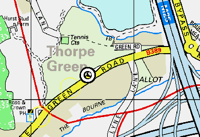
permission. The 1:5,000 street level map on the left is part of the sample which
Bartholomew permitted to be put on the UK Download page. Many other examples
will be found, each from a different organisation within the country concerned.
it
is possible to download non-detailed mapping (like the Boston map above) covering all
the country, plus sample maps of particular areas - with the copyright owners
permission. The 1:5,000 street level map on the left is part of the sample which
Bartholomew permitted to be put on the UK Download page. Many other examples
will be found, each from a different organisation within the country concerned.
Collaboration
We will be pleased
to hear from any overseas individual or company who wishes to collaborate in configuration of GPSS for use within their own country. This involves issues such as collection and conversion of suitable map data (e.g. locations of petrol filling stations), the spoken language, and the means of promotion and distribution.
Perhaps you can help by putting us in contact with PC Magazines who may publish
GPSS on their cover CD-ROMs, or GPS suppliers who can give GPSS away with
their receivers.
We are also happy to talk with any business who may wish to distribute GPSS with
their own software or data products. e.g. voice recognition software, mapping,
tourist information.